Synopsis:
It’ll be Tranquil times the next several days as we head into the weekend and Christmas Day. Abundant sunshine is anticipated. High pressure will dominate and readings won’t be too far off the seasonable average of the lower 40s through Saturday. By the Christmas Eve and Christmas Day a Southwest flow will develop around offshore high pressure. Readings will move to above average levels. It will be mild. Another Christmas that won’t be white. At least it won’t be freezing cold!
Winter arrives today at 10:27pm EST. This the moment when the sun’s direct rays are over the Tropic of Capricorn. This is also the day with the least amount of daylight.
Stay tuned.
Keep it here for a no nonsense, no hype forecast.
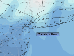
Thursday:
Sunny. Highs in the lower 40s. North winds at 8-12mph.
Tonight:
Mostly clear. Cold. Lows in the lower to mid 20s in the City, the teens inland. North winds at 5mph.
Friday:
Sunny. Chilly. Highs in the upper 30s.
Saturday:
Partly sunny. Highs in the lower 40s.
Christmas Eve:
Mostly sunny. Milder. Highs in the upper 40s.
Christmas Day:
Mostly sunny. Mild. Highs in the lower 50s.