Synopsis:
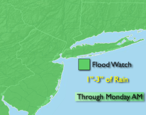
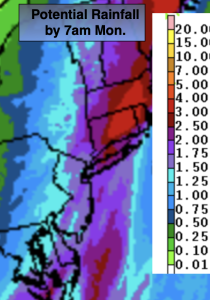
Low pressure will develop along a cold front over the Mid-Atlantic states tonight and be South of Eastern Long Island by sunrise Monday. The threat is there for strong winds at the coast and heavy rain in all areas tonight. A Flood Watch has been posted for the entire tri-state area for through Monday morning. One to three inches of rain is quite likely during this time period. A High Wind Warning has been Suffolk county Long Island and Southeast CT. Winds could gust between up to 60mph for a time overnight.
Cold air will be wrapping around on the Western side of the storm. Any rain could change over to a period of wet snow North and West late tonight and Monday morning. A slushy coating is possible over parts Sussex and Orange counties. All of the precipitation will come to an end by mid morning. The front and intensifying storm will move over Eastern New England and we’ll dry out with sunshine and gusty winds.
Tuesday thorough Thursday will feature abundant sunshine and chilly readings as high pressure settles over the Eastern states.
It’ll be a better feel by Friday as a southwest wind develops around the area of high pressure.
Stay tuned.
Keep it here for a no nonsense, no hype forecast.
Tonight:
Rain. Heavy at times. Windy at the coast. Lows in the 40s throughout, falling into the 30s by sunrise inland. South to Northwest winds at 15-25mph gusts to 35mph. Gusts between 50-60mph over Eastern Long Island and Southeastern CT.
Monday:
Early morning rain. Rain or wet snow inland. Becoming sunny during the morning. Windy. Highs in the mid 40s. Northwest winds at 15-30mph with gusts to 40mph.
Tuesday:
Sunny. Cool. Highs in the mid 40s.
Wednesday:
Mostly sunny. Highs in the lower to mid 40s.
Thursday:
Sunny. Highs around 40º.
Friday:
Sunny. Milder. Highs around 50º.