Synopsis:
The weekend won’t feel like December as a deep Southerly flow develops around a Western Atlantic high and developing storm over the Southern states. Today will be mild under a mix of clouds and sun with readings ten degrees above average. The average high is in the mid 40s.
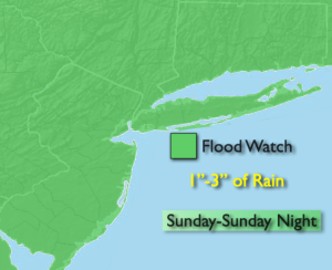
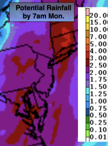
On Sunday, the intensifying storm will move into the Ohio Valley accompanied by a sharp cold front. Ahead of this system it’ll be balmy. Highs will be near 60º! Rain will be scattered during the morning (there will be dry times) but become more widespread during the afternoon.. The threat is there for strong winds and heavy rain Sunday night. A Flood Watch has been posted for the entire tri-state area for later Sunday into late Sunday night. One to three inches of rain is quite likely during this time period. A High Wind Watch has been posted for Queens, Brooklyn and Long Island for the same time period. Winds could gust between 50-60mph.
The rain will come to an end around sunrise Monday from West to East. The front and intensifying storm over Eastern New England pull away and we’ll dry out with sunshine and gusty winds.
Tuesday and Wednesday will feature abundant sunshine and cool readings as high pressure settles over the Eastern states.
Stay tuned.
Keep it here for a no nonsense, no hype forecast.
Saturday:
Clouds and sun. Mild. Highs in the mid to upper 50s. Southeast winds at 5mph.
Tonight:
Mostly cloudy. Chance of a few showers. Lows around 50º in the city, the 40s inland. Southeast winds less than 5mph.
Sunday:
Cloudy with intermittent rain in the morning. Rain becoming steadier later in the afternoon. Balmy. Highs around 60º.
Monday:
Partly sunny. Breezy. Highs in the mid 40s.
Tuesday:
Sunny. Cool. Highs in the mid 40s.
Wednesday:
Mostly sunny. Chilly. Highs in the lower 40s.