Synopsis:
High pressure will move off the Southeast coast today. This will result in more seasonable temperatures under a brighter sky.
The weekend won’t feel like December as a deep Southerly flow develops around a Western Atlantic high and developing storm over the Southern states. Saturday will be bright and mild with readings ten degrees above average. On Sunday, the intensifying storm will move into the Ohio Valley accompanied by a sharp cold front. Ahead of this system it’ll be balmy. Highs will be near 60º! Rain should hold off until later in the afternoon. The threat is there for a few hours strong winds and heavy rain Sunday night.
We’ll dry out on Monday behind the departing storm with sunshine and gusty winds.
Tuesday will feature abundant sunshine and cool readings as high pressure settles over the Eastern states.
Stay tuned.
Keep it here for a no nonsense, no hype forecast.
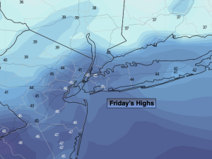
Friday:
Clouds and sun. More seasonable. Highs in the mid 40s. Northeast to Southeast winds less than 5mph.
Tonight:
Partly cloudy. Lows around 40º in the City, the upper 20s & 30s inland. Southeast winds at 5mph or less.
Saturday:
Sun and clouds. Mild. Highs in the mid 50s.
Sunday:
Mostly cloudy. Balmy. Rain developing during the afternoon. Highs around 60º.
Monday:
Partly sunny. Breezy. Highs in the mid to upper 40s.
Tuesday:
Sunny. Cool. Highs in the mid 40s.