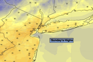
Synopsis:
Welcome to Eastern Standard Time. Where the sun sets earlier and the thoughts of Winter’s arrival becomes more of a reality.
Weather systems this upcoming week will be fairly weak and move rapidly as the jet stream is quite active.
Today will feature abundant sunshine and mild readings as high pressure move in from the West.
Seasonable temperatures (the upper 50s) are expected for Monday with the high over the region. It’ll be a sunny day.
Ahead of a rapidly moving cool front on Tuesday, readings will pop to well above average levels and then cool off again on Wednesday. Both days will feature plenty of sun.
Next in line on Thursday will be a weak low that a will traverse the Mid-Atlantic. Showers are in the forecast.
Stay tuned.
Keep it here for a no nonsense, no hype forecast.
Sunday:
Mostly sunny. Highs in the lower to mid 60s. Northwest winds at 5-10mph.
Tonight:
Mostly clear. Lows in the mid 40s along the urban corridor, the 30s inland. North winds at 5-10mph.
Monday:
Sunny. Seasonable. Highs in the upper 50s.
Tuesday:
Partly sunny. Mild. Highs in the mid 60s.
Wednesday:
Mostly sunny. Cooler. Highs in the mid 50s.
Thursday:
Mostly cloudy with the chance of showers. Highs in the upper 50s.