Synopsis:
Today will be around ten degrees warmer than Thursday. You’ll notice the difference. Readings will be near the average high of 58º under plenty of sunshine as high pressure settles over the East coast.
The first weekend of November will be a winner with abundant sunshine. Readings will be at or above average. A simple forecast and one without rain in the forecast!
It’s time to “Fall Back” Saturday night. Turn the clocks back one hour before hitting the hay. Eastern Daylight Time will end at 2AM and Eastern Standard Time will resume. We gain an hour of sleep! Sunrise will be an hour earlier Sunday, and sunset set will occur an hour earlier. Yep, darker earlier. It’s also a good time to change the batteries in your smoke and carbon monoxide detectors.
The beginning of next week will be tranquil as high pressure dominates. A weak front will approach later Tuesday with the threat of a few showers.
Stay tuned.
Keep it here for a no nonsense, no hype forecast.
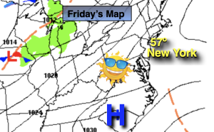
Friday:
Sunny. Highs in the mid to upper 50s. Southwest winds at 5-10mph.
Tonight:
Clear. Cold inland. Lows in the mid to upper 40s along the urban corridor, the 20s and 30s inland. Southwest winds at 5mph.
Saturday:
Mostly sunny. Milder. Highs in the lower 60s.
Sunday:
Mostly sunny. Highs in the upper 50s.
Monday:
Mostly sunny. Highs in the upper 50s.
Tuesday:
Partly sunny. Spotty afternoon showers possible. Mild. Highs in the mid 60s.