Synopsis:
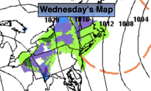
An offshore storm will continue to move out to sea today. Upper level energy and a surface trough from the low will cause areas of light rain through this morning. The best concentration of this looks to be in the NYC vicinity and to the North and East. A bit of light wet snow may fly over the higher elevations and areas that are cold enough to support the flakes. Welcome to November! It’ll be cold with a gusty wind as the sun returns for many during the afternoon.
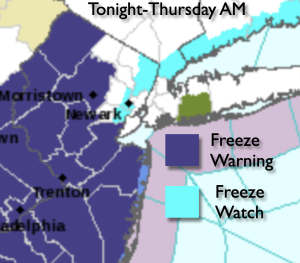
Freeze Warnings and Freeze Watches have been posted for tonight. Many areas will have their growing season end.
Chilly high pressure will move in for Thursday. Abundant sunshine with readings several degrees below the average high of the upper 50s is expected.
Friday will be more seasonable under plenty of sunshine as high pressure settles over the East coast.
The first weekend in November will be a winner with abundant sunshine and milder readings.
Stay tuned.
Keep it here for a no nonsense, no hype forecast.
Wednesday:
Areas of light rain, some wet light snow may mix in for a time in colder areas. Some afternoon sun. Cold. Highs in the 40s throughout. North/Northwest winds at 10-20mph.
Tonight:
Mostly clear and cold. Lows in the mid 30s along the urban corridor, the 20s to around freezing inland. Northwest winds diminishing to 5-10mph.
Thursday:
Sunny. Chilly. Highs in the upper 40s
Friday:
Sunny. Highs in the mid to upper 50s.
Saturday:
Sunny. Milder. Highs in the lower 60s.
Sunday:
Mostly sunny. Highs in the lower 60s.