Synopsis:
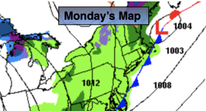
On and off showers are in the forecast though early afternoon Monday. Temperatures will be near seasonable levels of around 60º. To the South of the City a warm push of air may send temperatures will into the 60s and 70s. This is a low potential but needs to be mentioned. By late day temperatures will drop and the sun may make an appearance.
Trick or treaters will be dry this Halloween as cool air funnels down from the North. A mix of sun and clouds is expected with high pressure nosing in from the Northwest. there’ll be a nip in the air for sure.
Wednesday’s coastal storm will be offshore enough not to affect the region. This will result in a dry day, but quite chilly first day of November.
Chilly high pressure will move in for Thursday. Abundant sunshine with readings several degrees below the average high of the upper 50s is expected.
Friday will be more seasonable under plenty of sunshine as high pressure settles over the East coast.
Stay tuned.
Keep it here for a no nonsense, no hype forecast.
Monday:
Mostly cloudy. On and off showers. Highs in the 50s to around 60º. Warmer to the South. Temperatures falling during the afternoon. Winds becoming Northwest at 8-15mph with higher gusts late day.
Tonight:
Partly cloudy. Colder. Lows in the lower 40s along the urban corridor, the 30s inland. Northwest winds at 10-20mph.
Halloween:
Partly sunny. Chilly. Highs in the lower 50s.
Wednesday:
Sun and clouds. Highs in the 40s to around 50º.
Thursday:
Sunny. Highs in the lower 50s.
Friday:
Mostly sunny. Highs in the mid to upper 50s.