Synopsis:
High pressure to our West will be responsible for our chilly, bright conditions today. Readings will be a few degrees below the average high of the lower 60s.
Clear skies and calm winds tonight will result in the likelihood of scattered frost inland as readings flirt with the freezing mark.
The high will dominate our weather the entire week bringing with it delightful weather and the start of a significant warming trend. High will feel more like early June than later October!
Stay tuned.
Keep it here for a no nonsense, no hype forecast.
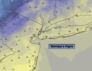
Monday:
Mostly sunny, breezy in the morning. Cool. Highs in the upper 50s. Northwest winds at 10-20mph and diminishing.
Tonight:
Clear. Lows in the upper 40s along the urban corridor, the 30s to around freezing inland. Light North wind.
Tuesday:
Sunny. Milder. Highs in the mid 60s.
Wednesday:
Sunny. Warmer. Highs in the lower 70s.
Thursday:
Sunny. Warm. Highs in the mid 70s.
Friday:
Mostly sunny. Warm. Highs in the mid 70s.