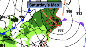
Synopsis:
This is our 7th consecutive Saturday with rain. Oy vey! Low pressure will move from just East of NYC this morning to Eastern New England by later today. On its journey it will intensify rapidly. There will be a shield of rain on the Western side of the storm that will affect much of the NYC vicinity this morning. The band of rain will move to the North and East during the afternoon. Rain will taper off along the urban corridor toward midday. Rain will continue for parts of Long Island and Connecticut during the afternoon. Farther to the West clouds should break for some sun. Winds will pick up behind the departing low. Gusts up to 35mph are likely. Secure any Halloween decorations!
The storm will become a powerhouse in Maine and the Canadian Maritimes on Sunday. Windy but dry conditions are expected. There will definitely be a nip in the air under a mix of clouds and sun.
It’ll be a bright and cool start to the week as high pressure moves in from the West on Monday. This high will settle over the region on midweek bringing with it delightful weather and the start of a warming trend.
Stay tuned.
Keep it here for a no nonsense, no hype forecast.
Saturday:
Areas of rain along the urban corridor this morning. Rain will taper off from West to East midday, but continue over parts of Long Island and Connecticut. The sun should make a visit for the Western burbs. Becoming windy during the afternoon. Highs in the lower 60s. Northwest winds at 15-25mph with gusts to 35mph.
Tonight:
Partly cloudy and windy. Lows in the 40s throughout. West to Northwest winds at a 10-20mph with gusts to 30mph.
Sunday:
Clouds and sun, windy and chilly. Highs in the mid to upper 50s.
Monday:
Mostly sunny. Cool. Highs in the upper 50s.
Tuesday:
Sunny. Seasonable. Highs in the lower to mid 60s.
Wednesday:
Sunny. Milder. Highs in the upper 60s.