Synopsis:
A large trough in the upper atmosphere will result in a couple of unsettled days. Low pressure will develop along the Virginia coast today resulting in on and off showers. There will be dry times. The low will move just East of NYC early Saturday morning. On and off rain is likely tonight into Saturday morning. Saturday will not be a washout. Morning showers will give way to some afternoon sun as the low continues its Northeast trek through Eastern New England. This will be our 7th consecutive Saturday with rain. Oy vey! Winds will pick up Saturday behind the departing low.
The storm will become a powerhouse in Maine and the Canadian Maritimes on Sunday. Windy but dry conditions are expected. There will definitely be a nip in the air under a mix of clouds and sun.
It’ll be a bright and cool start to the week as high pressure moves in from the West on Monday. This high will settle over the region on Tuesday bringing with it delightful weather and the start of a warming trend.
Stay tuned.
Keep it here for a no nonsense, no hype forecast.
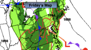
Friday:
Cloudy with on and off showers. Steadier rain at times from the City and to the East. Highs in the lower to mid 60s. Southeast winds at 8-12mph with gusts to 20mph.
Tonight:
On and off showers. Lows in the 50s throughout. Southeast to West winds at 5-10mph with gusts to 20mph.
Saturday:
Morning showers giving way to some afternoon sun. Becoming windy during the afternoon. Highs in the lower to mid 60s.
Sunday:
Clouds and sun, windy and chilly. Highs in the mid to upper 50s.
Monday:
Mostly sunny. Cool. Highs in the upper 50s.
Tuesday:
Sunny. Seasonable. Highs in the lower to mid 60s.