Synopsis:
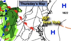
It’ll be a winner today with plenty of sunshine for a change as high pressure influences our conditions along the East coast. Readings will be around seasonable levels of the mid 60s.
A large trough in the upper atmosphere will result in a couple of unsettled days Friday and Saturday. Low pressure will develop along the Virginia the coast Friday resulting in on and off showers. The low will move just East of NYC early Saturday morning. On and off rain is likely Friday night into Saturday morning. The picture now is much clearer. Saturday will not be a washout. Morning showers will give way to some afternoon sun as the low continues its Northeast trek through Eastern New England. This will be our 7th consecutive Saturday with rain. Oy vey!
The storm will become a powerhouse in Maine on Sunday. Windy but dry conditions are expected. There will definitely be a nip in the air under a mix of clouds and sun.
It’ll be a bright and cool start to the week as high pressure moves in from the West.
Stay tuned.
Keep it here for a no nonsense, no hype forecast.
Thursday:
Mostly sunny. Milder. Highs in the mid 60s.
Tonight:
Increasing clouds. Lows in the 50s throughout. Light South wind.
Friday:
Cloudy with on and off rain. Highs in the lower 60s.
Saturday:
Morning showers giving way to some afternoon sun. Highs in the lower to mid 60s.
Sunday:
Clouds and sun, windy and chilly. Highs in the mid to upper 50s.
Monday:
Mostly sunny. Cool. Highs in the mid to upper 50s.