Synopsis:
A low pressure trough over the region would result in a familiar forecast for today. A mix of clouds and sun is expected. The chill will remain with readings about five degrees below the average high of the mid 60s.
Wednesday and Thursday will be winners as high pressure begins to build into the region. Abundant sunshine is expected with milder readings.
A Southerly flow will develop on Friday ahead of the next developing low pressure system to our South. Any sun will give way to clouds. Scattered showers are possible during the afternoon.
The computer models have shifted gears from what was once a steadier and heavier rain on Saturday to a more scattered showers outcome. This is due to low pressure not getting its act together until its North of the region. Many days to watch this unfold as we possibly encounter our 7th consecutive Saturday with rain. Oy vey!
Stay tuned.
Keep it here for a no nonsense, no hype forecast.
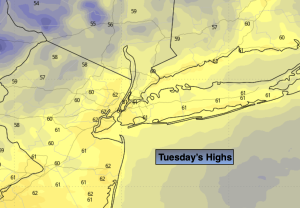
Tuesday:
Clouds and sun. Highs in the lower 60s. North winds at 5mph.
Tonight:
Mostly clear. Lows in the lower 50s in urban areas, the 40s inland. Light North wind.
Wednesday:
Sunny. Highs in the mid 60s.
Thursday:
Sunny. Milder. Highs in the upper 60s.
Friday:
Increasing clouds. Afternoon showers possible. Highs in the mid to upper 60s.
Saturday:
Threat of on and off showers. Highs in the lower 60s.