Synopsis:
Today will feature a low pressure trough over the region. A mix of clouds and sun is expected. Isolated showers are possible, the best chance is during the afternoon. It’ll be breezy and cool with readings about five degrees below the average high of the mid 60s.
More sun is expected for Tuesday as low pressure pushes out. The chill will remain.
Wednesday and Thursday will be winners as high pressure begins to build into the region. Abundant sunshine is expected with milder readings.
A Southerly flow will develop on Friday ahead of the next developing low pressure system to our South. Any sun will give way to clouds. Scattered showers are possible during the afternoon.
Stay tuned.
Keep it here for a no nonsense, no hype forecast.
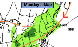
Monday:
More clouds than sun. Breezy and cool. Isolated afternoon showers possible, mainly during the afternoon. Highs around 60º.
Tonight:
Becoming mostly clear. Lows in the 40s to around 50º in urban areas. North wind diminishing to 5mph.
Tuesday:
Partly sunny. Highs in the lower 60s.
Wednesday:
Sunny. Highs in the mid 60s.
Thursday:
Sunny. Milder. Highs in the mid to upper 60s.
Friday:
Increasing clouds. Afternoon showers possible. Highs in the mid to upper 60s.