Synopsis:
Low pressure that gave the region rain for the first half of the weekend is quickly moving offshore today. More clouds than sun is expected. Temperatures will still be below average (the average high is in the mid60s), but at least we’ll see some sun! There’ll be a nip in the air with a gusty wind.
Monday will feature an upper level trough over the region. A mix of clouds and sun is expected. Isolated showers are possible during the afternoon.
More sun is expected for Tuesday as low pressure pushes out. The chill will remain.
Wednesday and Thursday will be winners as high pressure begins to build into the region. Abundant sunshine is expected with milder readings!
Stay tuned.
Keep it here for a no nonsense, no hype forecast.
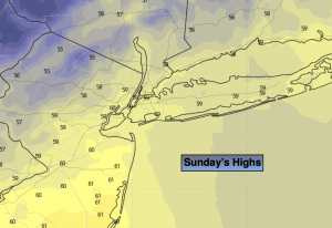
Sunday:
More clouds and sun. Breezy and cool. Highs in the upper 5os. Northwest winds at 15-25mph.
Tonight:
Becoming mostly clear. Lows in the 40s throughout. Northwest winds diminishing to 5-10mph.
Monday:
More clouds than sun. Isolated afternoon showers possible. Highs around 60º.
Tuesday
Partly sunny. Highs in the lower 60s.
Wednesday
Sunny. Highs in the mid 60s.
Thursday
Sunny. Milder. Highs in the mid to upper 60s.