Synopsis:
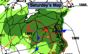
A dramatic change in weather will occur on Saturday as low pressure moves from the Ohio Valley to the Mid-Atlantic coast. Rain will develop this morning. It will be scattered at first then become steadier toward midday. It’ll be a raw day with readings ten degrees lower than the average high of the mid 60s. Rain is likely tonight. The low will exit quickly Sunday morning. Any early showers will give way to a mix of sun and clouds. Temperatures will still be below average, but at least we’ll see some sun!
Monday and Tuesday will feature an upper level low over the region. More clouds than sun is expected both days. Low pressure at the surface will develop offshore and move out to sea Tuesday. There is a threat of showers Tuesday. Signifiant rain at this time is not expected for the region.
Wednesday will feature more sun as high pressure begins to build into the region.
Stay tuned.
Keep it here for a no nonsense, no hype forecast.
Saturday:
Rain developing. Highs in the mid 50s. North to Northeast winds at 5-10mph.
Tonight:
Rain. Breezy. Lows in the 40s throughout. North to Northeast winds increasing to 10-20mph with higher gusts.
Sunday:
A morning shower, otherwise skies will become partly sunny. Highs in the upper 5os.
Monday:
More clouds than sun.. Highs around 60º.
Tuesday
More clouds than sun. Scattered showers possible. Highs in the upper 50s.
Wednesday
Mostly sunny. Highs in the lower 60s.