Synopsis:
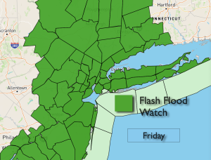
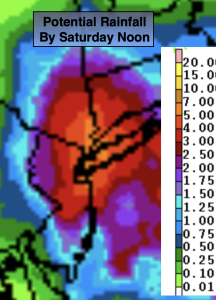
Well, here we go again. More rain is on the way. Low pressure off the coast, along with a trough extending into our region will bring on and off rain to the area tonight through Saturday morning. Some of the rain will be locally heavy. Where the heaviest axis of rain sets up won’t be determined until the system gets going on Friday. The potential for one to three inches with locally up to five inches of rain is on the table. The rainfall map above, as of this writing, is focusing the heaviest rain in and around the NYC area. Not good. The ground is completely saturated from previous rain early this week. It won’t take much for flooding to occur. A Flash Flood Watch has been posted for the area. If you encounter a flooded roadway- turn around, don’t drown.
Saturday will start off with clouds and the possibility of morning showers as once again we have a stubborn exiting low pressure. If we’re lucky we’ll get to see some late day sun.
October’s debut on Sunday looks spectacular with abundant sunshine and above average temperatures. The average highs are in the lower 70s. A string of beauties are expected well into next week!
Stay tuned.
Keep it here for a no nonsense, no hype forecast.
Tonight:
Cloudy. Periods of rain developing. Lows in the 50s throughout. Northeast winds at 8-15mph.
Friday:
On and off rain. Locally heavy. Highs around 60º. Northeast winds at 8-15mph.
Saturday:
Morning areas of rain, otherwise remaining mostly cloudy. A bit of late day sun is possible. Highs in the upper 60s.
Sunday:
Sunny. Warmer. Highs in the mid 70s.
Monday:
Sunny. Highs in the mid 70s.
Tuesday:
Sunny. Highs in the mid to upper 70s.