Synopsis:
A weak offshore frontal boundary will affect our weather the next coupe of days. Today will feature a mix of clouds and sun. It’ll remain dry with readings a few degrees below the average high of the lower 80s.
Tuesday and Wednesday will be humid with clouds dominating. Showers are likely just about anytime as the frontal boundary gets pushed up into the region from the Southeast. It will not be a washout.
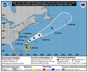
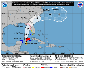
Hurricane Franklin will be moving between the the US mainland and Bermuda and what will be Hurricane Idalia will be making landfall along the big bend area of Florida (maps above). Tropical air tends to get thrown our way when systems are to our Southeast. Our area will only experience rough surf and rip currents from these storms.
The end of the week looks delightful with abundant sunshine and refreshing conditions as strong high pressure moves in.
Stay tuned.
Keep it here for a no nonsense, no hype forecast.
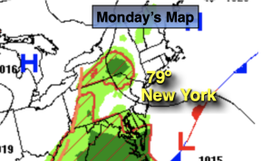
Monday:
Clouds and sun. Highs in the upper 70s. Southeast winds at 5-10mph.
Tonight:
Mostly cloudy. Scattered showers possible, mainly by the coast. Lows in the 60s throughout. Southeast to Northeast winds at 5mph.
Tuesday:
Mostly cloudy. Humid. Scattered showers possible. Highs in the mid to upper 70s.
Wednesday:
Mostly cloudy. Humid. Scattered showers possible. Highs near 80º
Thursday:
Mostly sunny, cooler. Much less humid. Highs in the mid 70s.
Friday:
Mostly sunny. Highs in the mid 70s.