Synopsis:
A warm front will move toward the region today. Clouds will dominate and scattered showers are likely. It’ll be unseasonably cool with readings eight to ten degrees lower than the average high of the lower 80s.
The front will push through the area Friday morning. A quick shot of rain is likely around sunrise. Some of the rain could be torrential. The rain will be over by mid-morning and the clouds will hang tough. It’ll become increasingly more humid.
By Saturday most of the moisture looks to clear the coast. At this time, JMW is keeping it dry with a mix of sun and clouds. The weather should cooperate for Sunday as well with high pressure nosing in from Eastern Canada. Readings both days will be near seasonable averages and the humidity levels will be way down. It’s looking like an A OK weekend!
Stay tuned.
Keep it here for a no nonsense, no hype forecast.
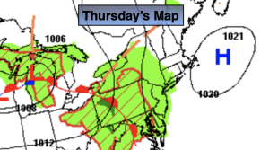
Thursday:
Grey skies with scattered showers. Cool. Highs in the lower to mid 70s. Southeast winds at 8-12mph.
Tonight:
Spotty showers possible. Lows around 70º in the City, the 60s inland. South winds at 8-12mph.
Friday:
Early morning rain, otherwise remaining cloudy. Humid. Highs in the 70s to around 80º.
Saturday:
Sun and clouds. Lowering humidity. Highs around 80º.
Sunday:
Mostly sunny. Highs around 80º.
Monday:
Mostly sunny. Highs in the upper 70s.