Synopsis:
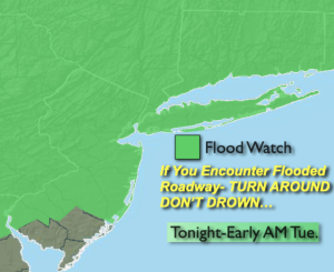
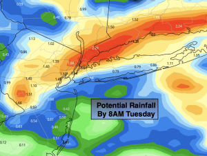
Low pressure and it’s associated fronts will work into the tri-state area through Tuesday night. A quick punch (think 3-6 hours) of heavy rain and storms is likely overnight between 11pm and 5am. Some areas not get into the intense rainfall rates (map above). With the potential of torrential rain, a Flood Watch has been posted for the entire area. Never drive through a flooded roadway. You don’t know how deep the water is. Turnaround, don’t drown.
Scattered showers are possible Tuesday morning. The majority of the day looks dry. A weak front will be over the region. A few scattered evening and nighttime showers and storms are possible as the front moves to the coast.
Weather systems will be weak Wednesday and Thursday. This will result in decent days with plenty of sun and seasonable readings. A weak cool front will approach Friday with a few more clouds but no rain is anticipated.
The weekend looks stellar with abundant sunshine and warm readings as high pressure builds over the region.
Stay tuned.
Keep it here for a no nonsense, no hype forecast.
Tonight:
Scattered showers and storms. Locally heavy rain is possible. Humid. Lows in the lower to mid 70s in the City, near 70º inland. Southeast winds at 5mph.
Tuesday:
Scattered morning showers, otherwise more clouds than sun. Humid. Chance of scattered evening showers and storms. Highs in the lower to mid 80s.
Wednesday:
Mostly sunny. Highs in the lower to mid 80s.
Thursday:
Partly sunny. Highs in the lower to mid 80s.
Friday:
Partly sunny. Highs in the mid 80s.
Saturday:
Sunny. Highs in the mid 80s.