Synopsis:
A disturbance from the West will move through our region today and tonight. Spotty showers are possible. The greatest threat will be later in the afternoon and evening. At this point it doesn’t look too widespread or heavy and there will definitely be dry times.
The weekend looks stellar as high pressure builds over the region. Any morning clouds on Saturday will give way to mostly sunny skies. Temperatures will be near seasonable averages-the mid 80s. Another beauty is expected for Sunday with similar conditions.
We may have to contend with a few showers on Monday as a warm front works through.
Tuesday should be dry with a fair amount of sun.
Readings the next five days will be near average or just below the average high of the mid 80s.
Stay tuned.
Keep it here for a no nonsense, no hype forecast.
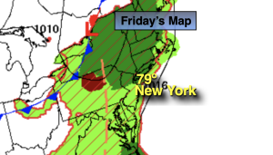
Friday:
Mostly cloudy. Spotty shower. Most of the time will be dry. Highs around 80º. Southwest to South winds at 8-15mph.
Tonight:
Mostly cloudy. A few showers and an isolated storm possible. Lows in the 60s throughout. Southwest to West winds at 5-10mph.
Saturday:
Becoming mostly sunny. Highs in the mid 80s.
Sunday:
Sunny. Highs in the mid 80s.
Monday:
Sun and clouds. Chance of showers and isolated storms. Highs in the lower to mid 80s.
Tuesday:
Partly sunny and warm. Highs in the mid 80s.