Synopsis:
High pressure will move off the coast today. This will result in our continuation of delightful August weather. A mix of sun and clouds is expected with readings a few degrees below the average high of the mid 80s.
A warm front will push through our region on Friday. Scattered showers and thunderstorms are possible. The greatest threat will be later in the afternoon and evening. At this point it doesn’t look too widespread or heavy.
Any morning clouds on Saturday will give way to mostly sunny skies. Temperatures will be near seasonable averages-the mid 80s. Another beauty is expected for Sunday with similar conditions.
We may have to contend with a few showers on Monday as another warm front works through.
Stay tuned.
Keep it here for a no nonsense, no hype forecast.
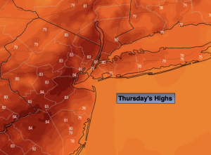
Thursday:
Partly sunny. Highs in the lower 80s. Southwest to South winds at 10-20mph.
Tonight:
Mostly cloudy. A few showers are possible. Lows in the 60s throughout. Southwest winds at 5-10mph.
Friday:
Mostly cloudy. Scattered showers and storms most likely later in the day. Highs around 80º.
Saturday:
Becoming mostly sunny. Highs in the mid 80s.
Sunday:
Sunny. Highs in the mid 80s.
Monday:
Sun and clouds. Chance of showers and isolated storms. Highs in the lower to mid 80s.