Synopsis:
It’s the beginning of a heat wave as high pressure off the coast becomes a Bermuda high. This is typical for this time of the year. Today and Friday will be quite hot and humid under hazy skies. The heat index will reach between 100º-106º both days. Please drink plenty of fluid, try to stay out of the heat of the day between 11am-4pm. Wear light weight, light colored clothing. Check on the elderly and pets often.
There is a storm threat for later today into this evening as a weak front approaches from the West. Some of the storms maybe severe. Eye to the sky for threatening weather after 3pm.
On Saturday a cool front will approach later in the day with a scattered storm. It’ll still be hot.
Relief will arrive on Sunday as a Canadian airmass moves in. Temperatures will be near the seasonable averages of the mid 80s.
Stay tuned.
Keep it here for a no nonsense, no hype forecast.
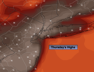
Thursday:
Hazy, hot and humid. Breezy. Scattered late day storms are possible. Highs in the mid 90s. Heat index: 100º-106º. Southwest winds at 10-20mph with gusts to 30mph.
Tonight:
Mostly clear and warm. Lows in the upper 70s in the City, the upper 60s to lower 70s inland. West winds at 5mph or less.
Friday:
Hazy, hot and humid. Highs in the mid 90s. Heat index: 100º-106º.
Saturday:
Hazy, hot and humid. An isolated late day storm is possible. Highs in the lower 90s.
Sunday:
Mostly sunny. Cooler. Highs in the lower to mid 80s.
Monday:
Sunny. Highs in the mid 80s.