Synopsis:
The best chance of showers and possible storms will be this morning. The latest computer guidance has it much drier the rest of the day. There will be some sun with the latest development in the near-term weather pattern.
The weekend will make most smile. Drier conditions are expected with the sun dominating both days as high pressure builds over the area. A winner for sure!
Hazy, very warm and humid conditions are expected for the beginning of the week with high pressure dominating. Typical July conditions for sure.
Stay tuned.
Keep it here for a no nonsense, no hype forecast.
Friday:
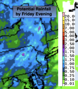
Clouds to some sun. Humid. Scattered showers and storms mainly for the first half of this morning. The rest of the day will be mainly dry. Highs around 80º. Northeast to Southeast winds at 5-10mph.
Tonight:
Partly cloudy. Cooler. Lows in the upper 60s in the City, the upper 50s and 60s inland. Northwest winds at 5mph.
Saturday:
Mostly sunny, not as humid. Highs in the mid 80s.
Sunday:
Sunny. Highs in the mid to upper 80s.
Monday:
Mostly sunny. Highs in the mid to upper 80s.
Tuesday:
Partly sunny. Highs in the mid to upper 80s.