Synopsis:
Typical July conditions will be with us through Friday. A mix of sun and clouds is expected as a weak disturbance sits over the region. A late day storm threat is possible today and Friday-Friday being the best chance. Readings will be near the seasonable average of the mid to upper 80s.
By Saturday, enough of a push from the West will result in drier conditions under sunny skies.
Stay tuned.
Keep it here for a no nonsense, no hype forecast.
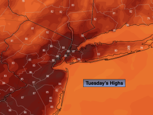
Tuesday:
An isolated shower this morning, otherwise hazy sun. Scattered showers and storms later in the day. Highs in the upper 80s. South winds at 5-10mph.
Tonight:
An isolated evening storm, otherwise partly cloudy. Lows in the lower 70s in the City the 60s inland. South to Northwest winds at 5mph.
Wednesday:
Partly sunny. Warm. Highs in the upper 80s.
Thursday:
Partly sunny. Highs in the mid to upper 80s.
Friday:
Partly sunny. Scattered showers and storms likely. Highs in the mid 80s.
Saturday:
Mostly sunny, not as humid. Highs in the mid 80s.