Synopsis:
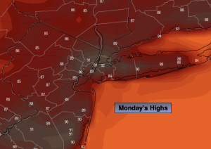
A welcome change to drier conditions is expected for Monday. Bright, hot and smokey conditions are anticipated as weak high pressure develops over the region. Smoke from the Canadian wildfires will affect our region once again. Readings will be about five degrees above the average high of 85º.
Typical July conditions will continue Tuesday through Friday under a mix of sun and clouds as a weak disturbance sits over the region. A late day storm threat is possible on Tuesday, Thursday and Friday. It will not be a washout.
Stay tuned.
Keep it here for a no nonsense, no hype forecast.
Monday:
Mostly sunny, smokey and hot. Highs around 90º. Southwest winds at 5-10mph.
Tonight:
Partly cloudy. Lows in the mid 70s in the City the upper 60s inland. South winds at 5mph.
Tuesday:
Partly sunny. Scattered showers and storms later in the day. Highs in the upper 80s.
Wednesday:
Mostly sunny. Warm. Highs in the upper 80s.
Thursday:
Partly sunny. Scattered showers and storms later in the day. Highs in the mid to upper 80s.
Friday:
Partly sunny. Scattered showers and storms later in the day. Highs in the mid to upper 80s.