Synopsis:
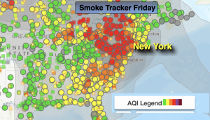
Today will be day two of the smoke. High pressure will move off the coast. This will result in mainly sunny skies and warm readings. Temperatures will be seasonable for the last day of June. Average highs are around 84º.
The beginning of the 4th of July weekend on Saturday looks like a winner. Mostly sunny skies are expected. The threat of scattered showers and storms will be with us Sunday and Monday as a warm front and weak disturbance affects the region. It’ll be hazy and humid. It will not be a washout. Readings will be around the seasonable averages.
The 4th of July forecast on Tuesday looks more optimistic. The disturbance should move out to sea leaving the area with a bright sky and warm conditions.
Stay tuned.
Keep it here for a no nonsense, no hype forecast.
Friday:
Mostly sunny. Smokey skies. Seasonable. Highs in the mid 80s. Southeast winds at 5-10mph.
Tonight:
Mostly clear. Lows around 70º in the City, around 60º inland. Light Southeast winds.
Saturday:
Mostly sunny. Highs in the mid 80s.
Sunday:
More clouds than sun. Scattered showers and storms. Humid. Highs around 80º.
Monday:
Sun and clouds. Scattered PM showers and storms. Humid. Highs in the mid 80s.
4th of July:
Sun and clouds. Highs in the mid 80s.