Synopsis:
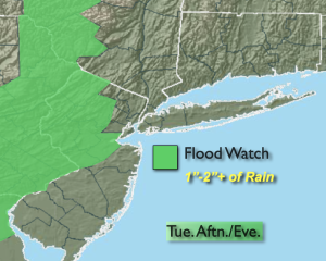
Weak low pressure over the Northeast will be responsible for the shower and storm threat through Wednesday. It will not be a washout, but areas that get into the heavier rain in the Flood Watch area can have a repeat performance with flooding later today.
The clouds will win the battle today. Scattered showers and storms will develop after 3pm. It’ll be humid. Some of the rain will be torrential. Never drive through flooded roadways. You can’t judge how deep the water is- TURN AROUND, DON’T DROWN. The storms later today will not be as widespread or intense as yesterday.
By Thursday and Friday the disturbance will be weakening and moving to the Northeast. This will result in mainly sunny skies and warmer readings.
The beginning of the 4th of July weekend on Saturday will feature a mix of sun and clouds. Showers and storms are possible in the afternoon as a warm front approaches.
Stay tuned.
Keep it here for a no nonsense, no hype forecast.
Tuesday:
Mostly cloudy. Chance of showers and storms later in the day. Humid. Highs in the upper 70s. South winds at 8-12mph.
Tonight:
Scattered showers and storms early. Muggy. Lows in the mid to upper 60s throughout. Southeast winds 5mph.
Wednesday:
Sun and clouds. Chance of afternoon showers. Highs in the upper 70s.
Thursday:
Sun and clouds. Highs in the lower to mid 80s.
Friday:
Mostly sunny. Highs in the mid 80s.
Saturday:
Sun and clouds. Scattered PM showers and storms. Highs around 80º.