Synopsis:
Weak low pressure over the Northeast will be responsible for the shower and storm threat through Wednesday. It will not be a washout.
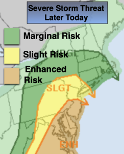
A mix of sun and clouds is expected for Monday. Widely scattered showers and isolated storms are possible for the first half of the day. Much of the time will be dry. It’ll be warm with readings getting above the average high of the lower 80s by a few degrees. The humidity will be noticeable. There’s a slight to enhanced risk of severe thunderstorms later this afternoon and evening. Damaging winds, torrential rain and frequent cloud to ground lighting is possible. Keep an eye to the sky for threatening weather after 2pm.
Scattered showers and storms are possible for the first half of tonight.
The threat of showers and storms will continue Tuesday and Wednesday with an upper lower pressure system moving slowly through. Again, it will not be a washout.
By Thursday and Friday the disturbance will be weakening and moving to the Northeast. This will result in dry conditions and warmer readings.
Stay tuned.
Keep it here for a no nonsense, no hype forecast.
Monday:
Sun and clouds. Humid. Spotty PM showers and storms. Highs in the mid 80s. Southeast winds at 8-12mph.
Tonight:
Scattered showers and storms early. Muggy. Lows around 70º in the City, the mid 60s inland. Southeast winds 5mph.
Tuesday:
Sun and clouds. Chance of showers and storms. Highs in the upper 70s.
Wednesday:
Sun and clouds. Chance of showers. Highs in the upper 70s.
Thursday:
Sun and clouds. Highs in the lower 80s.
Friday:
Sun and clouds. Warmer and more humid. Highs in the mid 80s.