Synopsis:
Weak low pressure over the Northeast will be responsible for the shower and storm threat through Thursday. It will not be a washout.
Today will be mainly sunny for the first half of the day. It’ll heat up with readings getting above the average high of the lower 80s by a few degrees. The humidity will be noticeable. Scattered showers and storms are possible during the afternoon and evening with the heating of the day. This forecast can be applied to Monday as well.
The threat of showers will continue into midweek with an upper lower pressure system moving slowly through.
By Thursday, the threat of showers will be minimal.
Readings will be just below seasonable averages though midweek.
Stay tuned.
Keep it here for a no nonsense, no hype forecast.
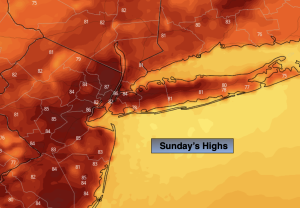
Sunday:
Sun and clouds. Warm and humid. Spotty PM showers and storms. Highs in the mid 80s. Southeast winds at 5-10mph.
Tonight:
Isolated showers or storm. Muggy. Lows around 70º in the City, the mid 60s inland. Southeast winds less than 5mph.
Monday:
Sun and clouds. Humid. Spotty PM showers and storms. Highs in the mid 80s.
Tuesday:
Chance of showers. Highs in the upper 70s.
Wednesday:
Chance of showers. Highs in the upper 70s.
Thursday:
Sun and clouds. Spotty showers possible. Highs around 80º.