Synopsis:
The next five days will not be a washout.
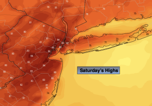
A weak low over the Mid-Atlantic will move North Saturday. Any morning showers will taper off. There will be dry times under a mix of clouds and hazy sun. It’ll be warmer. Readings will be near the average highs of the lower 80s. Spotty storms are possible during the afternoon.
High pressure will continue to shift off the coast during the weekend. This will result in a Southerly flow of humid air. A mix of sun and clouds is expected Sunday with a chance of scattered afternoon and evening showers and storms. It will not be a washout.
The humidity will remain high through Monday. Like Sunday, hazy skies are expected with scattered afternoon storms.
The threat of showers will continue into midweek with an upper lower pressure system moving slowly through.
Stay tuned.
Keep it here for a no nonsense, no hype forecast.
Saturday:
Morning showers ending. Some hazy sun. Warmer and more humid. Spotty PM showers and storms. Highs in the lower 80s. South wind at 5-10mph.
Tonight:
Isolated showers and storms. Muggy. Lows around 70º in the City, the mid 60s inland. Southwest winds less than 5mph.
Sunday:
Sun and clouds. Humid. Spotty PM showers and storms. Highs in the mid 80s.
Monday:
Sun and clouds. Humid. Spotty PM showers and storms. Highs in the mid 80s.
Tuesday:
Chance of showers. Highs in the upper 70s.
Wednesday:
Chance of showers. Highs in the upper 70s.