Synopsis:
High pressure will continue to build over the Northeast through midweek. This will keep our area dry. There will be clouds from time to time from a Southern low trying to nudge North. Temperatures will be below the seasonable average of the lower 80s the next several days.
Moisture from a weak low over the Southern Appalachians will move North on Thursday and Friday. All of the computer models now have showers in our area for Thursday. The threat of showers will stick around Friday but it won’t be steady or widespread.
The high will shift off the coast on Saturday. This will result in a Southerly flow of humid air. A mix of sun and clouds is expected with a chance of a few showers. It will not be a washout.
Stay tuned.
Keep it here for a no nonsense, no hype forecast.
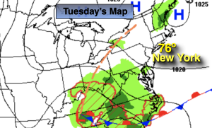
Tuesday:
Clouds and sun. Slightly cooler. Highs in the mid 70s. East to Southeast winds at 5-10mph.
Tonight:
Partly cloudy. Lows in the lower 60s in the City, the 50s inland. East winds at 5mph.
Wednesday:
Sun and clouds. Highs in the lower 70s.
Thursday:
Cloudy with showers likely. Cool. Highs around 70º.
Friday:
Sun and clouds. Scattered showers. Highs in the upper 70s.
Saturday:
Sun and clouds. Humid. Spotty showers. Highs in the lower 80s.