Synopsis:
Some fine mid-June conditions are expected today. An upper level low North of New England will result in a Northwest flow of seasonable air. This will be our brief break day from the rain threat.
Low pressure at the surface will affect our region on Friday with another round of scattered showers and isolated storms.
The low will weaken over Northern New England on Saturday. There will still be enough energy associated with this feature to keep the threat of scattered showers in the forecast. It’ll be cooler than average. The average high is around 80º.
The weather will make most dads smile on Father’s Day. A dry Northwest flow will result in abundant sunshine and warm readings!
Stay tuned.
Keep it here for a no nonsense, no hype forecast.
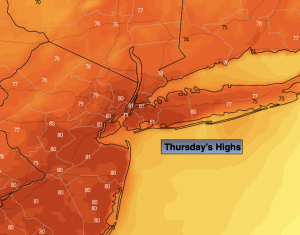
Thursday:
Mostly sunny. Highs around 80º. West to Northwest winds at 8-12mph.
Tonight:
Mostly clear. Lows in the mid 60s in the City, the 50s inland. West to Southwest winds less than 5mph.
Friday:
More clouds than sun. Scattered showers and thunderstorms possible during the afternoon. Highs in the mid 70s.
Saturday:
More clouds than sun. Scattered showers possible. Highs in the mid 70s.
Father’s Day:
Mostly sunny. Seasonable. Highs in the lower 80s.
Monday:
Mostly sunny. Highs in the upper 70s.