Synopsis:
Scattered showers are possible on Monday afternoon as a front approaches from the West. The good news is scattered areas of heavy rain will develop after 4pm, mainly over the Northern half of NJ and to the North. We desperately need the rain. Hopefully, your area will receive beneficial rain this evening.
A winner is expected Tuesday with higher pressure building for a time. Scattered showers and storms are possible Wednesday afternoon as weak low pressure moves to our North.
Some fine mid-June conditions are expected Thursday and Friday. An upper level low North of New England will result in a Northwest flow of seasonable air.
Stay tuned.
Keep it here for a no nonsense, no hype forecast.
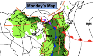
Monday:
More clouds than sun. Seasonable and breezy. Scattered showers during the afternoon. There will be more dry times than wet times. Areas of heavier rain and thunderstorms are in the forecast after 4pm for the Northern half of the region. Highs in the upper 70s. Southeast winds at 8-15mph with gusts to 25mph.
Tonight:
Areas of rain and isolated storms during the evening. Clearing skies after midnight. Lows in the mid 60s in the City, the upper 50s to around 60º inland. Southeast to Northwest winds at 5-10mph.
Tuesday:
Mostly sunny. Highs around 80º.
Wednesday:
Sun and clouds. Scattered showers and thunderstorms possible. Highs in the mid to upper 70s.
Thursday:
Mostly sunny. Highs around 80º.
Friday:
Partly sunny. Highs around 80º.