Synopsis:
A ridge of high pressure will build off the Southeast coast today. It’ll be a Summer preview with readings five to seven degrees above the average high of the upper 70s. Winds will veer to the South. There still be some smoke to contend with as much of the Eastern and Southeastern seaboard has residual smoke from days past. The level of smoke will be on the lower side but will be visible with that “look”.
Scattered showers are possible on Monday as a front approaches from the West. The good news is scattered areas of heavy rain will develop after 4pm. We desperately need the rain.
A winner is expected Tuesday with higher pressure building for a time. Isolated showers are possible Wednesday as weak low pressure moves to our North. Another winner is expected for Thursday.
Stay tuned.
Keep it here for a no nonsense, no hype forecast.
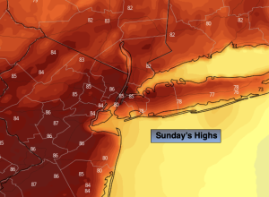
Sunday:
Mostly sunny. Warmer. Areas of light smoke. Highs in the mid 80s. Cooler at the coast. Southeast winds at 8-12mph.
Tonight:
Partly cloudy. Mild. Lows in the mid to upper 60s in the City, around 60º inland. South winds at 5-10mph.
Monday:
More clouds than sun. Scattered showers. There will be more dry times than wet times. Areas of heavier rain after 4pm. Isolated thunderstorms possible. Highs in the upper 70s.
Tuesday:
Mostly sunny. Highs around 80º.
Wednesday:
Sun and clouds. Isolated showers possible. Highs in the upper 70s.
Thursday:
Partly sunny. Highs around 80º.