Synopsis:
The weak surface and upper level low will continue to lose it’s influence over the region today. This will result in a decent weekend with abundant sunshine, limited smoke and warming temperatures for Saturday. A ridge of high pressure will build off the Southeast coast on Sunday. It’ll be a Summer preview with readings five to seven degrees above the average high of the upper 70s. Winds will veer to the South. This is good news for the smoke situation as the fires are well to the North. The smoke will be traveling away from our area and not towards like the last several days.
Scattered showers are possible on Monday afternoon as a front approaches from the West.
A winner is expected Tuesday with higher pressure building for a time. Isolated showers are possible Wednesday as weak low pressure moves to our North.
Stay tuned.
Keep it here for a no nonsense, no hype forecast.
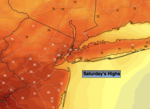
Saturday:
Mostly sunny. Milder. Highs in the upper 70s. Northwest winds at 8-12mph.
Tonight:
Mostly clear. Milder than recent nights. Lows in the mid to upper 60s in the City, the 50s inland. Light Winds.
Sunday:
Mostly sunny. Warmer. Highs in the mid 80s.
Monday:
Sun and clouds. Afternoon showers possible. Highs in the upper 70s.
Tuesday:
Partly sunny. Highs around 80º.
Wednesday:
Sun and clouds. Isolated showers possible. Highs in the upper 70s.