
Synopsis:
Conditions through continue to be dominated by slowly moving low pressure over the Northeast. This will result in a persistent Northwest Flow. Because of this, temperatures will be below average once again today. The average highs are in the mid to upper 70s. The low will pivot into Southern New England. The will result in mainly cloudy skies with the chance of showers this afternoon.
Air quality has been improving and this trend will most likely continue as winds begin to switch direction and some of the wildfires over Quebec become more contained.
By the weekend, the low will finally weaken and move out to sea. Mainly sunny skies are expected as a ridge of high pressure works into the region. Temperatures will be in near seasonable averages on Saturday and rise to warm levels on Sunday.
Scattered showers are possible on Monday as a front approaches from the West. The shower threat will continue into Tuesday morning.
Stay tuned.
Keep it here for a no nonsense, no hype forecast.
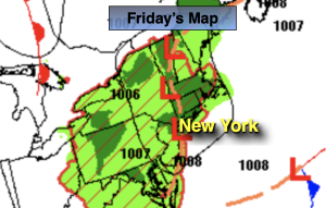
Friday:
Mostly cloudy. Spotty late day and evening showers. Cool. Highs in the 60s to around 70º.
Tonight:
Mostly cloudy with scattered showers this evening. Lows in the mid to upper 50s in the City, around 50º inland. Light Winds.
Saturday:
Mostly sunny. Milder. Highs in the mid 70s.
Sunday:
Mostly sunny. Warmer. Highs in the lower 80s.
Monday:
Sun and clouds. Afternoon showers possible. Highs in the mid 70s.
Tuesday:
Morning showers to sunshine. Highs around 80º.