Synopsis:
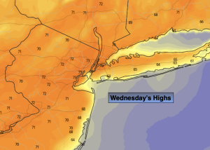
A top ten day is in store for Wednesday. Wall to wall sunshine with readings a few degrees above the average high of 70º is anticipated. High pressure developing over the Northeast is responsible for our midweek delight.
It’ll be a June feel tomorrow and Friday as the high slips off the coast. Readings will be at least ten degrees above average with abundant sunshine.
A bit of a hiccup is now in the forecast for Saturday. It looks like a front will move into the region from the North. The threat of showers has now been introduced into the forecast for the morning hours. Hopefully, this will be a quick event as JMW is anticipating the sun to return during the afternoon hours. It’ll still be warm.
Mother’s Day will be a winner. Plenty of sunshine and near seasonable readings are expected as high pressure moves in from the Northwest.
Stay tuned.
Keep it here for a no nonsense, no hype forecast.
Wednesday:
Bright and pleasant. Highs in the lower to mid 70s. Northwest to Southwest winds at 8-12mph.
Tonight:
Clear. Lows in the upper 50s in the City, the 40s inland. Southwest to West winds at 5mph.
Thursday:
Sunny, Warmer. Highs around 80º.
Friday:
Mostly sunny. Warm. Highs in the lower 80s.
Saturday:
The threat of morning showers, otherwise becoming mostly sunny. Highs around 80º.
Mother’s Day:
Sunny, breezy and seasonable. Highs in the lower 70s.