Synopsis:
A weak frontal boundary may cause a spotty shower South of the City today, otherwise a mix of sun and clouds is expected with just below average readings. The average high is 70º.
The Wednesday through Saturday period looks bright and pleasant as high pressure reorganizes along the Eastern Seaboard. A warming trend will begin and readings by week’s end will be about ten degrees above the average high of 70º. A June feel for sure!
Stay tuned.
Keep it here for a no nonsense, no hype forecast.
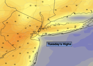
Tuesday:
Clouds, some sun. Spot shower possible South. Cooler. Highs in the mid to upper 60s. Northeast to East winds 5-10mph.
Tonight:
Mostly clear. Lows in the lower 50s in the City, the upper 30s and 40s inland. East to Northwest winds less than 5mph.
Wednesday:
Bright and pleasant. Highs around 70º.
Thursday:
Sunny, Warmer. Highs around 80º.
Friday:
Mostly sunny. Warm. Highs in the lower 80s.
Saturday:
Mostly sunny. Warm. Highs in the lower 80s.