Synopsis:
Rainfall from the one, two punch of storms was eye opening. Between 2.5″ and 7″ of rain fell across our region. We’ll get to dry out today behind the deepening storm to our North. The sun will finally return for a time but clouds will win the battle during the day. An isolated shower can’t be ruled out later in the day and evening. It’ll be breezy.
An upper level low will spin over the Northeast and remain basically stationary. This will result in a basically what you see is what you get forecast. More clouds than sun is expected with spotty showers and unseasonably cool temperatures. Welcome to May.
Stay tuned.
Keep it here for a no nonsense, no hype forecast.
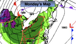
Monday:
Early sun, otherwise mostly cloudy. Isolated shower possible late. Highs in the lower 60s. West to Southwest winds at 15-25mph.
Tonight:
An isolated early shower otherwise, partly cloudy and cool. Lows in the upper 40s in the City, near 40º inland. Southwest diminishing to 5-10mph.
Tuesday:
More clouds than sun. Spotty showers. Cooler. Highs in the mid to upper 50s.
Wednesday:
More clouds than sun. Spotty showers. Chilly. Highs in the mid 50s.
Thursday:
More clouds than sun. Spotty showers. Highs in the upper 50s.
Friday:
More clouds than sun. Spotty showers. Highs in the upper 50s.