Synopsis:.
Rain will end from West to East later this AM. The sun will make an appearance for the second half of the day as the front and low pressure along it move to the North and East. Readings will be a few degrees above the average high of 65º.
Cool, tranquil conditions are expected Monday through Thursday as high pressure dominates. A mix of clouds and sun is expected.
Stay tuned.
Keep it here for a no nonsense, no hype forecast.
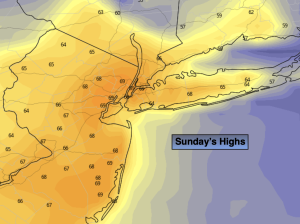
Sunday:
Rain will end from West to East later this morning. Skies will break for sun from time to time. Highs in the upper 60s. West to Northwest winds at 8-15mph.
Tonight:
Partly cloudy. Lows in the upper 40s in the City, the the upper 30s and lower 40s inland. Northwest winds at 5-10mph.
Monday:
Partly sunny. Highs in the lower 60s.
Tuesday:
Partly sunny. Cool. Highs in the lower 60s.
Wednesday:
Partly sunny. Cool. Highs in the lower 60s.
Thursday:
Partly sunny. Cool. Highs in the lower 60s.