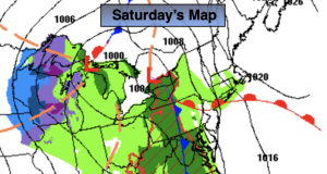
Synopsis:.
A moist flow off the ocean will result in areas of clouds and fog this morning. Today will be dry. A warm front will move North through the Southern 1/2 of the area during the day This will result in a large difference in temperatures from the coast to well inland through the day. Areas well away from the ocean will be warm on Saturday, while some coastal communities will be almost twenty degrees cooler. This is very typical in the Spring in our region. Once the clouds burn off this morning, partly sunny skies are expected. The winds will be busy this afternoon and gust up to 30mph out of the Southeast.
A significant cold front will move into the region on tonight. The rain will work in between 8pm-11pm from West to East.
Morning clouds and showers East will give way to times of sun and clouds Sunday afternoon. Readings will be a few degrees above the average high of 65º.
Cool conditions are expected Monday through Wednesday as high pressure works in from the West. A mix of clouds and sun is expected.
Stay tuned.
Keep it here for a no nonsense, no hype forecast.
Saturday:
Areas of clouds and morning fog giving way to partly sunny skies. Breezy and mild. Highs in the lower 70s in the City. Warmer inland, cooler at the coast. East to Southeast winds increasing to 10-20mph with gusts to 30mph.
Tonight:
Rain will develop between 8-11PM. Lows in the lower to mid 50s in the City, the the upper 40s and lower 50s inland. Southeast to East winds at 8-12mph.
Sunday:
Morning clouds and showers East giving way to a mix of sun and clouds. Highs in the mid 60s.
Monday:
Partly sunny. Highs in the lower 60s.
Tuesday:
Partly sunny. Cool. Highs around 60º.
Wednesday:
Partly sunny. Cool. Highs around 60º.