Synopsis:.
After two days with record breaking high temperatures in the 90s, it’s back to reality. Readings will be around twenty five degrees cooler for highs. Clouds will win the battle as a Southerly flow brings up some moisture. Saturday morning should be dry. Scattered showers are likely by afternoon. Sunday should be mainly dry but mainly grey. Readings will still be several degrees above the average high of 61º.
A cool front move through the region on Monday. A few showers are possible during the morning, otherwise the sun will return.
Tuesday will feature much cooler readings under a mix of sun and clouds as a Canadian air mass makes a visit.
Temperatures will moderate to seasonable averages by midweek under abundant sunshine as high pressure dominates.
Stay tuned.
Keep it here for a no nonsense, no hype forecast.
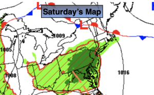
Saturday:
More clouds than sun. Much cooler. Scattered afternoon showers likely. Highs around 70º. Southeast winds at 5-10mph.
Tonight:
A spot shower early, otherwise mostly cloudy. Lows in the 50s throughout. Southeast to East winds less than 5mph.
Sunday:
Mostly cloudy. Cooler. Highs in the mid 60s.
Monday:
A spotty morning shower, otherwise a mix of sun and clouds. Highs in the mid 60s.
Tuesday:
Mostly sunny. Cooler. Highs in the upper 50s.
Wednesday:
Mostly sunny. Seasonable. Highs in the lower to mid 60s.