Synopsis:.
Our string of beautiful days will continue through the week. Temperatures will moderate rapidly as high pressure anchors itself along the Southeast coast. June-like readings and abundant sunshine is the forecast through Friday- a Summer preview for sure!
The weekend at this time looks cooler with a mix of clouds and sun as a Southerly flow brings up some moisture. A spot shower is possible but I wouldn’t cancel any outdoor plans!
Stay tuned.
Keep it here for a no nonsense, no hype forecast.
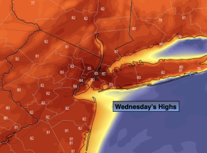
Wednesday:
Morning clouds to sun. Much warmer. Highs in the lower to mid 80s. West winds at 10-20mph.
Tonight:
Clear. Unusually warm. Lows in the mid 60s in the City (this is warmer than the average high of 60º!), the 50s all other locations. Light West winds.
Thursday:
Sunny. Very Warm. Highs in the mid 80s.
Friday:
Mostly sunny. Very Warm. Highs in the mid 80s.
Saturday:
Clouds and sun. Not as warm. Spot shower possible. Highs in the mid 70s.
Sunday:
Clouds and sun. Cooler. Spot shower possible. Highs in the upper 60s.