Synopsis:.
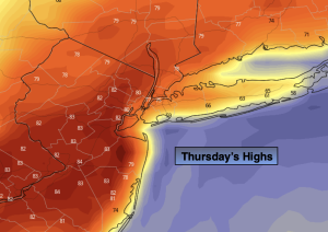
Another 360º turn in the weather will occur today. After morning clouds and fog burn off skies will become partly sunny. Readings will feel like late June! Highs will be more than twenty five degrees warmer than Wednesday as high pressure moves off the coast and a Southwest flow will take hold. There is a chance of afternoon and evening showers and storms as a cool front approaches.
More seasonable readings (the upper 50s) are expected on Friday into Easter weekend as strong high pressure dominates the Northeast. A delightful holiday weekend is on the way. Some may call it egg-cellent!
The tranquil conditions will continue into early next week.
Stay tuned.
Keep it here for a no nonsense, no hype forecast..
Thursday:
Morning clouds and patchy fog will give way to a mix of sun and clouds. Temperatures will pop and become quite warm. Chance of afternoon scattered showers. Highs in the upper 70s to lower 80s. Cooler over parts of Long Island and the immediate coast. Southwest to Northwest winds at 8-15mph with gusts to 25mph.
Tonight:
Spotty evening shower or storm otherwise, becoming partly cloudy. Lows in the 40s throughout. Northwest winds at 8-12mph.
Friday:
Mostly sunny. More seasonable. Highs in the mid to upper 50s.
Saturday:
Sunny. Highs in the mid 50s.
Easter:
Sunny. Highs in the mid to upper 50s.
Monday:
Sunny. Highs around 60º.