Synopsis:
March will come in like a lamb. The sun will shine for a brief break as high pressure says a quick hello.
A weak low will move through the region tonight ad Thursday morning with scattered showers. The sun will return by afternoon with readings well above average- a Spring feel once again for sure.
The next storm is on the map for Friday. The exact track (like always in Winter) will determine the type of precipitation. As of this writing the storm will take an inland track-a warm solution. Mainly rain is expected along the coast with any mix or ice North and West going over to rain Friday night. This system looks to carry with it copious amounts of precipitation into Friday night as a secondary storm develops along the Delmarva and moves just Southeast of NYC.
Skies will remaining mostly cloudy on Saturday but it should be rain-free as the system pulls into the Atlantic.
Sunday will feature a mix of sun and clouds with seasonable readings.
Stay tuned.
Keep it here for a no hype, no nonsense forecast.
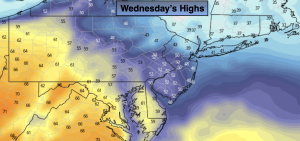
Wednesday:
Sun to late clouds. Highs mid 40s. Northeast to Southeast winds at 5mph.
Tonight:
Scattered showers. Lows in the lower 40s in the City, the 30s inland. East to Northeast winds at 5mph.
Thursday:
Morning showers to sunshine. Much warmer. High well into the 50s.
Friday:
Rain. A mix possible well North and West. Highs in the 30s and 40s.
Saturday:
Clouds early with increasing sunshine. Highs in the mid to upper 40s.
Sunday:
Partly sunny. Highs in the mid 40s.