Synopsis:
Sun will give way to clouds today with seasonable readings as high pressure retreats into Northern New England. Light snow will break out during the evening from West to East.
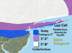
A storm will develop over the Ohio Valley and redevelop along the Mid-Atlantic coast Monday night and move offshore Tuesday. Enough cold air will be just in place that the potential for an accumulating snow has increased for the Northern 1/2 of the region.
Snow will come down heavy at times later this evening through late tonight in the areas of the higher two bands (majority of the NYC vicinity). The bust zone is the Southern most swath. Since readings will be near freezing the colder surfaces are where the potential totals will be reached. Farther to the South, any frozen precipitation will go over to rain. Light snow, mix or light rain will continue into the first half of Tuesday. Clouds will hang tough,
The sun will return for a brief break on Wednesday as high pressure says a quick hello.
A weak low will move through the region on Thursday morning with scattered showers. The sun will return with readings well above average- a Spring feel once again for sure.
The next storm is on the map for Friday. The exact track (like always) will determine where the snow, mix or rain will fall. This system looks to carry with it copious amounts of precipitation.
Stay tuned.
Keep it here for a no hype, no nonsense forecast.
Monday:
Sun to clouds. Light snow developing during the evening hours. High in the lower to mid 40s. North to Southeast winds at 5-10mph.
Tonight:
Snow, heavy at times for the Northern half of the region for a few hours. Mix to rain to the South. Lows in the lower to mid 30s. Near 30º inland. East to Northeast winds increasing to 10-20mph with gusts to 30-35mph at the coast.
Tuesday:
Light snow, mix or drizzle in the morning depending on location. Any light precipitation will slowly come to end later in the day. Highs in the upper 30s to mid 40s.
Wednesday:
Sunny. Highs mid 40s.
Thursday:
Morning showers to sunshine. Much warmer. High well into the 50s.
Friday:
Snow, mix, rain. Highs in the 30s and 40s.