Synopsis:
A storm will develop over the mid-section of the country today. The track of the low will move well to our North and West. A warm front associated with the storm will move our way later today with afternoon rain a bit of sleet or wet snow may fall North and West. Showers will taper off late tonight.
On Thursday, temperatures will depend on your location. A warm front will straggle the region and may move as far North as the Western suburbs of NYC. North and East of the City, temperatures will remain in the 40s under mainly cloudy skies. To the South and West of the City another Spring fling is possible. Here the sun should break out and this region has the potential for readings to skyrocket well into the 60s.
A gusty Northwest wind will develop around a deepening storm South of Nova Scotia on Friday. A mix of sun and clouds are expected with readings dropping into upper 30s later in the day.
February will return on Saturday with highs only in the 30s as a Canadian airmass moves in courtesy of high pressure. Skies will be mainly sunny. Sunday will be Midler half of the weekend under a mostly sunny sky temperatures will rise to several degrees above the average high of the lower 40s.
Stay tuned.
Keep it here for a no hype, no nonsense forecast.
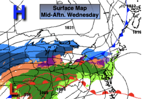
Wednesday:
Any morning sun giving way to thickening clouds and afternoon showers. Some sleet and wet snow possible for the Northwestern third of the tri-state area. Cooler. High in the lower 40s, 30s inland. Northwest to Southeast winds at 5mph.
Tonight:
Showers ending this evening, otherwise mostly cloudy. Lows in the 30s throughout. East to Northeast winds at 5mph.
Thursday:
Mostly cloudy North and East with readings in the 40s. Becoming partly sunny South and West with readings in the 60s.
Friday:
Partly sunny. Breezy. High in the 40s dropping into the 30s during the afternoon.
Saturday:
Mostly sunny. Cold. High in the mid 30s.
Sunday:
Mostly sunny. Milder. High in the mid to upper 40s.