Synopsis:
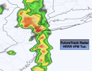
Tuesday’s skies will remain mostly cloudy. A weak punch of energy will move in later in the day with scattered showers.
Skies will become partly cloudy overnight with readings inland falling below freezing.
A storm will develop over the mid-section of the country Wednesday. The track of the low will (like all its predecessors) move well to our North and West. This is a no snow solution. A warm front associated with the storm will move our way later Wednesday with afternoon showers a bit of sleet may mix in into the night, especially North and West. Morning showers on Thursday should give way to mostly cloudy skies. Both Wednesday’s and Thursday’s temperatures will be near the average high of the lower 40s. The warmer air over the Washington DC, Baltimore area will not make it this far North.
A gusty Northwest wind will develop around a deepening storm South of Nova Scotia on Friday. A mix of sun and clouds are expected with readings dropping into upper 30s later in the day.
February will return on Saturday with highs only in the 30s as a Canadian airmass moves in courtesy of high pressure. Skies will be mainly sunny.
Stay tuned.
Keep it here for a no hype, no nonsense forecast.
Tuesday:
Early morning rain or snow showers East, otherwise mainly cloudy with scattered showers later in the day. Highs in the upper 40s. Northeast to North winds at 5mph.
Tonight:
Clearing skies. Lows in the mid 30s in the City, the 20s inland. Northwest winds at 8-12mph.
Wednesday:
Any morning sun giving way to thickening clouds and afternoon showers. Some sleet possible for the Northern half of the tri-state area. Cooler. High in the lower 40s, 30s inland.
Thursday:
Morning showers, otherwise mostly cloudy. High in the upper 30s and 40s, the 50s and 60s over Southwestern section of the tri-state area.
Friday:
Partly sunny. Breezy. High in the 40s dropping into the 30s during the afternoon.
Saturday:
Mostly sunny. Cold. High in the mid 30s.