Synopsis:
Low pressure will move will into extreme Northern New England today. A cold front associated with the storm will sweep through the our region during the midday hours. Morning highs will be Spring-like, then drop during the day. This will be the third consecutive day with readings above 60º for New York City. 70º was the high on Thursday. Simply amazing for February. By days end, most of the region will have readings drop into the 40s under the return of a bit of sun.
Typical Winter conditions will make a brief visit tonight. All readings will be below freezing with a gusty wind under starlit skies. Something we haven’t experienced in weeks.
Saturday we’ll finally contend with seasonable readings for daytime highs as cooler high pressure takes hold. The chill won’t last as the high move offshore and the mild return flow greet us for the second half of the weekend. Both days will feature mainly sunny skies.
On Presidents’ Day temperatures will once again reach early Spring readings ahead of an approaching cold front under as mix of sun and clouds. Tuesday will be no different with above average readings continuing.
Stay tuned.
Keep it here for a no hype, no nonsense forecast.
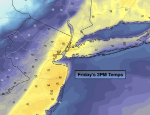
Friday:
Morning areas rain will give way to some mid to late afternoon sun. Warm to start. Temps will drop during the day. Becoming windy. AM highs in the 50s & 60s falling to the upper 40s by late day. Southwest to Northwest winds at 15-25mph with gusts to 35mph.
Tonight:
Clear, windy and much colder. Lows in the mid 20s in the City, around 20º inland. Northwest winds at 15-25mph with gusts to 35mph.
Saturday:
Sunny. Seasonable. High in the lower 40s.
Sunday:
Partly sunny, mild. High around 50º.
Presidents’ Day:
Partly sunny, mild. High in the mid 50s.
Tuesday:
Partly sunny. High in the upper 40s.